Written By: Laura Cooley and Brianne Minton, AUWRC
Two years ago, the Auburn University Water Resources Center, Alabama Extension, and the Alabama State Climate Office saw a need to work together to improve drought communications and drought agricultural impact monitoring in Alabama. Through a collaborative effort, they hired Brianne Minton to coordinate a new statewide drought program called Alabama Drought Reach (ADR).
As program coordinator, Brianne has spent the last ten months increasing public drought literacy by writing communication pieces for Extension, speaking at conferences, engaging with growers, and strengthening the foundational relationship between Extension and the AL State Climate Office. Much of her time has been spent learning how drought impacts farmers directly and finding ways to proactively monitor conditions in preparation for future droughts. What she has found is that a loss to our farmers is a loss to us all.

Brianne Minton (ADR Program Coordinator) Speaking at a Conference. Photo Credit: Dr. Brenda Ortiz
Impacts of Drought in Alabama
Drought affects everyone in different ways, but it has major impacts on our agricultural community. Alabama’s 37,000 farms span nearly 8.6 million acres, provides jobs to 600,000 Alabamians, and produces roughly $9 billion in agricultural products. Drought affects not only farmers relying on their commodities to make a living but also the public who utilizes those commodities for foods and materials.
Luckily, many farmers impacted by drought can apply for federal relief funding through USDA. Some of this funding, however, is contingent on farms falling within certain drought categories on the U.S. Drought Monitor (USDM) map. The USDM is a federal product created by the National Drought Mitigation Center, USDA, and NOAA to classify drought severity and location across the United States.
The AL State Climate Office is our state organization that provides input on Alabama specific conditions to the U.S. Drought Monitor. When Alabama farmers fall within certain criteria of the USDM map, they can become eligible for USDA relief funding during times of drought. The AL State Climate Office has a lot of resources to make these informed decisions, but you can also provide on-the-ground drought observations that can help them make a more accurate Alabama drought map.

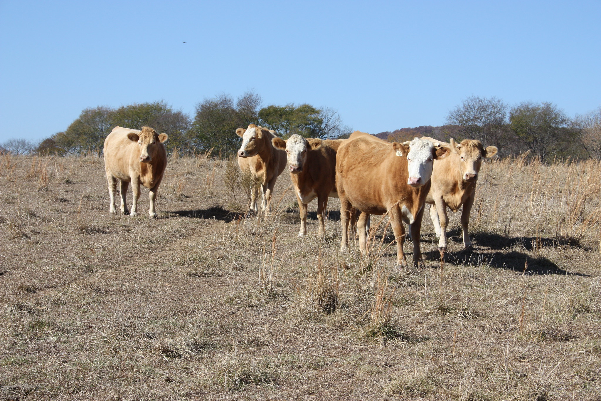
Cattle Unable to Graze During 2019 Drought. Photo Credit: Bruce Dupree
CMOR (Condition Monitoring Observer Reports) is a public tool created by the National Drought Mitigation Center in partnership with the National Integrated Drought Information System and the USDA. It allows anyone to report drought-related conditions and impacts on their property. You do not have to be a farmer to complete this survey. Even dry conditions in your back yard can provide useful data for the AL State Climate Office. Submitting a CMOR report is quick and easy, and your report becomes a permanent record that can help inform more accurate drought maps of Alabama. Submitting a report can be a way to support the agricultural community.
Aside from reporting, Alabama Drought Reach is also working to keep Alabama citizens informed on drought conditions by creating infographics with data compiled by the U.S. Drought Monitor and the AL State Climate Office. These Alabama Drought Updates include past and present drought conditions, climate highlights from the AL State Climate Office, and the drought forecast for the upcoming week.
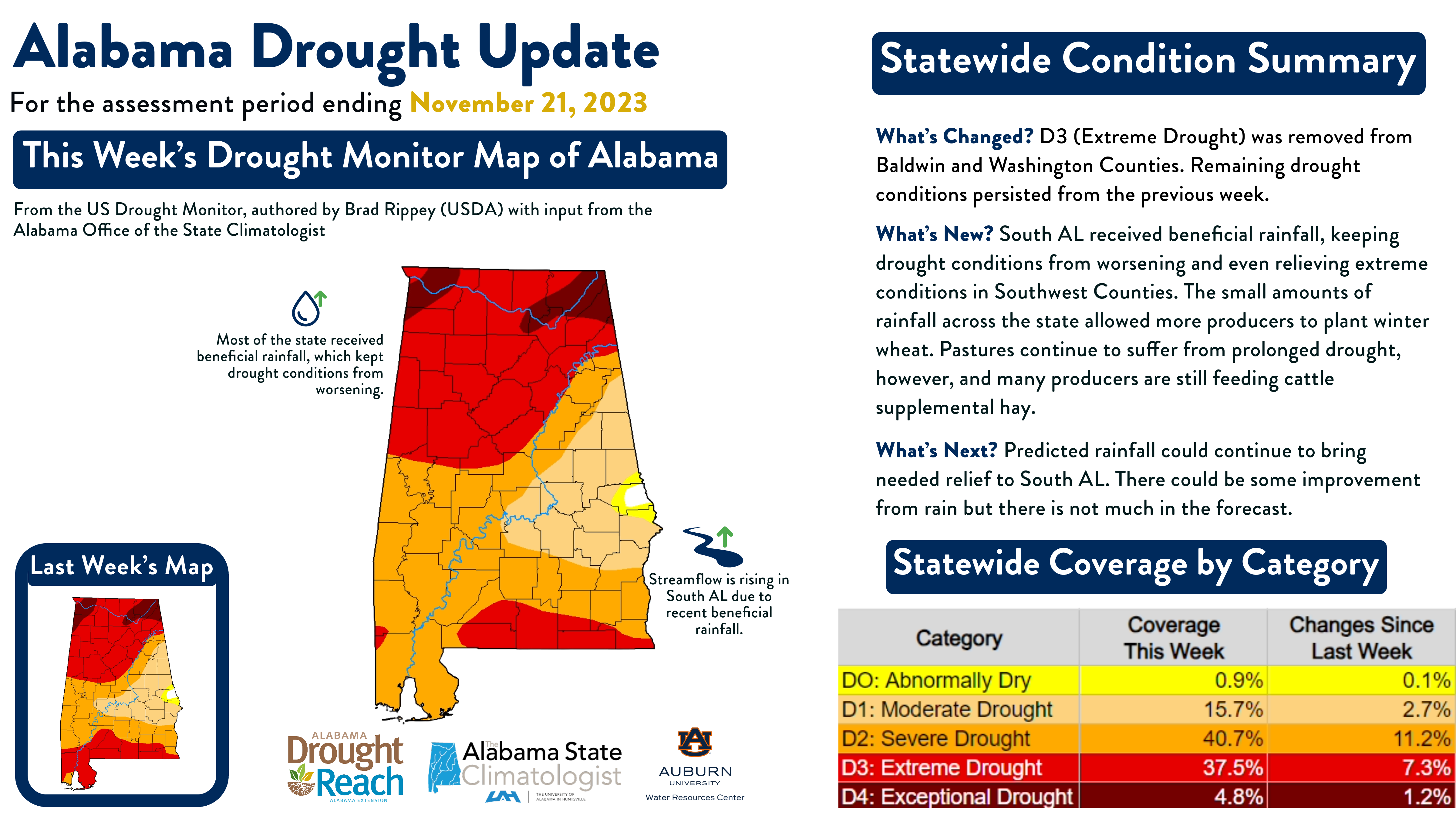
The example below showcased some of the worst conditions from the Fall 2023 drought. The large map in the center shows the location of drought on November 21, 2023. The colors on the map correspond to one of the five USDM drought categories, which can be seen in the statewide coverage table. Note that D0 (Abnormally Dry) indicates dryness but not actual drought. D1 (Moderate Drought) is the first official drought category. According to this visual, most of the state was experiencing either Severe or Extreme Drought. The statewide coverage table tells you what percentage of the state is experiencing each level of drought and the percentage change in drought severity from the previous week. For example, 40.7% of Alabama was in D2 (Severe Drought) on November 21, which was an 11.2% change from the previous week.
The small map in the bottom left corner serves as the visual reminder of what drought conditions looked like from the previous week. The icons surrounding the central map indicate climatological trends that the AL State Climate Office wants to highlight. For this week, they wanted to highlight the beneficial rainfall that kept conditions from worsening and the increase in streamflow after months of serious drought. Lastly, the statewide condition summary on the right features the overall drought trends that week. “What’s Changed” specifically outlines changes in drought severity. “What’s New” talks about climatological patterns in drought indicators like precipitation and temperature. “What’s Next” forecasts potential drought trends for the following week based on rainfall predictions.
Drought impacts us all. Alabama is one of the first states to utilize a program like Alabama Drought Reach to proactively prepare for and mitigate drought impacts. Visit www.aub.ie/drought to learn more about the Alabama Drought Reach program and stay up to date on statewide drought conditions by following their Twitter (@ALDroughtReach).

Nov. 21, 2023 AL Drought Update – Example of Graphic Made by Alabama Drought Reach
